Inventar 2126
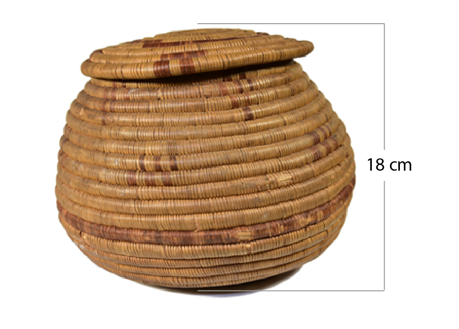 |
Korb mit Deckel
Hersteller*in: unbekannt 18 cm hoch, 24 cm im Durchmesser. Geographische Herkunft: Namibia Provenienz: |
|
Werner Denzel, als Spende seit 2010 in der Sammlung. Werner Denzel (*11.01.1904 – Todesdatum und –ort unbekannt) reiste 1930 in das heutige Namibia ein. Er arbeitete nachweislich als Buchdrucker und Setzer in Otjiwarongo. Das Objekt wurde 2010 von seinem Neffen an das DITSL übergeben. Über die genauen Erwerbsumstände der Objekte ist bisher noch nichts weiter bekannt |
Inventar 2130
Inventar 2132
Inventar 2129
Subcategories
About
Rangeland-based livestock production is a major land use system that contributes between 15 and 60 percent of the agricultural GDP in eastern and southern African countries. The growth of rangeland vegetation is highly variable in space and time, occurring in temporary patches.
Knowledge of rangelands is crucial to their management and strategic use of resources. Local communities have developed strategies that are grounded in cultural practices, stories, ethics, and norms specific to their area. These strategies also require access to up-to-date information on heterogenous and seasonal resource availability.
However, site-specific information on the condition and intensity of use of rangeland resources is rarely available or accessible to herders in real-time. Consequently, incomplete or outdated information is often the basis on which pastoralists make decisions.
Information and communication technologies (ICT) have enormous potential to provide easily accessible up-to-date information to increase efficiency based on spatial data generation, telemetry services, GPS navigation services, and mobile phone network services, reliably facilitated by an ever-growing system of private and public satellites.
To successfully co-develop technology, InfoRange uses a transdisciplinary approach to create the ICT solutions together with users in a way that embeds them in social innovations. Through an actor- and activity-oriented approach, we build on the knowledge of different involved actor groups to understand how their decision-making can be improved through ICT.
Linking digital solutions to the existing system offers opportunities for the community to improve their information gathering and sharing and make it more effective. In addition, digitization can facilitate communication between various stakeholders, such as veterinarians, authorities regulating water supply in pasture areas, or government agencies involved in other pastoral services.
- You are here:
-
Home

-
deutsche Inhalte
-
Kultur & Kunst
- Inventory Online


 NaviNut